Tõramaa wooded meadow campfire site
Viljandi County, Soomaa National Park
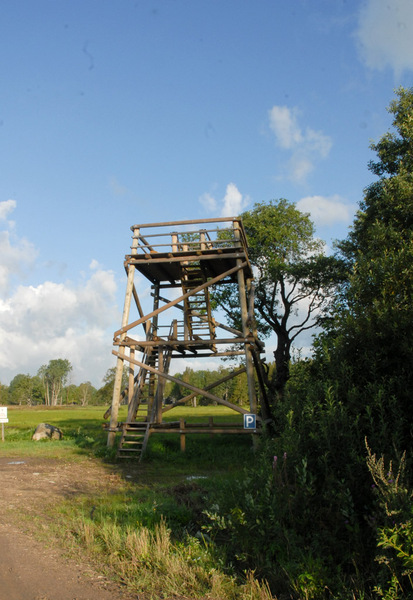
The wooded meadow of Tõramaa is near the Halliste River. In the campfire site it is possible to have a picnic and camp. There is a solid shelter to protect you from bad weather. Those interested in birds and animals can use the observation tower.
| Phone | +372 526 1924 |
|
info.soomaa@rmk.ee
| |
| Type of object | Campfire site |
| Parking facilities | Parking area for 3 cars |
| Amenities | Fire ring with barbecue grill, shelter, dry toilet, observation tower |
| Camping facilities |
Allowed is 1 tent (for 4). |
| Campfire site | Fire ring with a grill. |
| Sights | Restored flood-meadow, the Halliste River, wooded meadow, large wild animals, attractive bird species. |
| Additional information |
|
| Restrictions | In the territory of the National Park certain restrictions. Further information can be obtained from the Environmental Board (+372 662 5999, info@keskkonnaamet.ee). |
| Location | Tipu village, Põhja-Sakala municipality, Viljandi County. Object no 21 on the national park map. |
| Driving directions | The campfire site of Tõramaa wooded meadow is located in Tipu village, on the border of Viljandi and Pärnu counties, at the end of the path going from the Kõpu-Jõesuu road (24 km from Kõpu) to the meadow. When coming from the direction of Tallinn-Pärnu-Tori, drive to Tori, turn onto the Võlli road that leads to the national park. Drive 6 km along the Jõesuu road to Jõesuu village and before driving into the village, turn right onto Kõpu-Jõesuu road. It is 14.4 km to the Nature Centre of the national park and the campfire site of Tõramaa wooded meadow from there. When you get to the sign directing you to the Nature Centre, drive 500 m, where a sign directs you to the 2.2-km trail that takes you to the campfire site. When coming from Tartu or Viljandi, drive along Tartu-Viljandi-Pärnu road to the settlement of Kõpu. After passing the cemetery, turn right to the Kõpu-Jõesuu road – it is 23.8 km to the Tõramaa campfire site. When you get to the sign, turn left, where a 2.2-km trail takes you to the campfire site. |
| Geographic coordinates | Long-Lat WGS 84 latitude: 58.422235 longitude: 24.996989 |
| L-EST 97 x: 6476195.3 y: 558253.7 |